Showing posts with label maps and earth. Show all posts

Connect with people and places you love this Valentine’s Day

A few months ago, we shared an engagement story about a Google engineer who used Google Maps to help coordinate an elaborate proposal to his girlfriend. It served as a great example of how Google Maps can be more than just a handy tool for directions; it can help connect you to the places and people you love.

With Valentine’s Day right around the corner, we were once again reminded of the unifying power of maps through our ongoing work with one of America’s most famous malls, Mall of America in Bloomington, Minnesota. We recently collaborated with Mall of America to conveniently bring its indoor floor plans and My Location information to Android mobile users. As the largest indoor retail space in the United States—complete with a theme park and aquarium—finding your way around Mall of America can be challenging. So we mapped it, enabling you to quickly and easily see where you are and what’s around you from the palm of your hand.

Check out the video below to see how the enormous Mall of America can be scaled down to a romantic setting for two.


Whether it’s through a customized scavenger hunt, search results for a local store with the perfect gift or the best directions to get to your date on time, we hope Google Maps helps you navigate your way to a wonderful Valentine’s Day.


(Cross-posted from the Lat Long blog)

Catch the London Underground with Google Maps

(Cross-posted on the Lat Long Blog)

Starting today, you can get public transport directions for London within Google Maps. One of Europe’s largest metropolitan areas, London is a major destination for both business travelers and tourists. More than 1 billion passengers are serviced by Transport for London (TfL) every year across over 18,000 bus stops and over 250 Underground stations.

Let’s say you’re at Trafalgar Square, and you want to visit Madame Tussauds. With a simple directions search, you’ll see all the possible public transport connections. In Maps, click “Get directions” in the left-hand panel, and then the train icon to see public transport directions. Enter your departure location next to A, and your destination next to B. These can be either street addresses or names of popular places, businesses or restaurants. When you’re done, click the “Get directions” button and suggestions for your trip will appear below.


Public transport directions are available on both Google Maps and Google Maps for mobile, so you always have access to a trip planner. When you’re on mobile, Maps even uses your current location to determine the best trip to your destination. Just search for your destination location, select it on the map and choose the “Directions” option. The suggested trips will be based on your location by default, and provide you multiple alternatives whenever possible.

If you’re using an Android-powered device, you can also get public transport directions with Transit Navigation (Beta) in Google Maps. With this new feature, which we launched earlier this month, you’ll get alerts when it’s time to get off the bus or train at your destination or to make a transfer. Transit Navigation is available in all regions where public transport directions are available, including London.


TfL is among the first agencies in a major European city to make its timetable information publicly available through the London Datastore. We’re strong supporters of open data and bringing information out into the open, and believe that making information publicly accessible can be an enormous engine of economic growth and innovation. ITO World has been a great partner in this launch by ensuring TfL’s data was adapted correctly and ready for our use.

Public transport directions are available for all Underground, bus, tram and Docklands Light Railway (DLR) lines, and we’ll include more public transport information as soon as it’s available. Whether you use public transport every day or infrequently, as a commuter, on a business trip or as a tourist, we hope that public transport directions in London make planning your trips more convenient!

Congratulations Russia, the National Geographic World Champions

(Cross-posted from the Lat Long and Student Blogs)

This island has a population of about 57,000 people, with the most settlements concentrated on the west coast. Very little of this island is suitable for agriculture.

After eight rounds of questions from none other than quiz king Alex Trebek himself, the team from Russia was crowned the National Geographic World Champions today at our Mountain View, Calif. headquarters after answering this final question correctly.

(By the way, the answer is Greenland.)


The National Geographic World Champions from Russia (photo courtesy of National Geographic)

Students from 17 regions around the world competed in the 2011 National Geographic World Championship. Today’s final round included answering a series of challenging questions like the one above. The students also interpreted maps and museum artifacts from the University of California Berkeley and fielded questions about live animals from the San Francisco Zoo during the earlier rounds of the competition.

Congratulations to the Russian team and to all of the students who participated. We look forward to seeing where your explorations and knowledge take you.

“Download map area” added to Labs in Google Maps for Android

(Cross-posted from the Mobile and Lat Long Blogs)

One way we bring you new product features is through Google Labs—a collection of fun, experimental features you can turn on if you’re interested in the functionality. In fact, Google Maps itself started as a lab. In addition to our desktop Maps Labs, Google Maps for Android has a few tricks you can try out right from your phone. We’d like to introduce you to one new experimental feature, “Download map area," but also remind you of two other ones we already have: “Scale bar” and “Measure.”

Download map area
When you’re visiting an unfamiliar location, Google Maps for mobile is great for getting an idea of how close you are to your destination, where streets and landmarks are in relation to each other, or just for getting “un-lost.” But what if you don’t have a data signal, or you’re abroad and don’t have a data plan? We say that if you use Google Maps for mobile, you’ll never need to carry a paper map again. The “Download map area” lab in Google Maps 5.7 for Android is a step in making that statement true even when you’re offline.

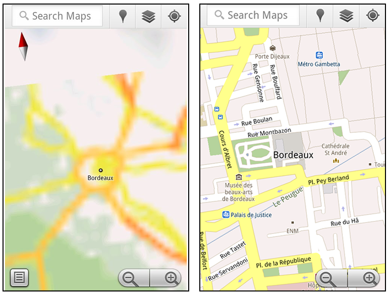
Let’s say later you’re visiting Bordeaux during a trip to France. If you were to open Google Maps for mobile and zoom into Bordeaux without data coverage or wifi, you’d see the image on the left:


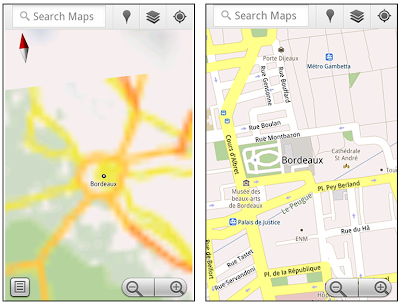
Left: Bordeaux with no data or wifi. Right: Bordeaux with downloaded map area

That’s not particularly useful when you’re trying to find out how close you are to the 
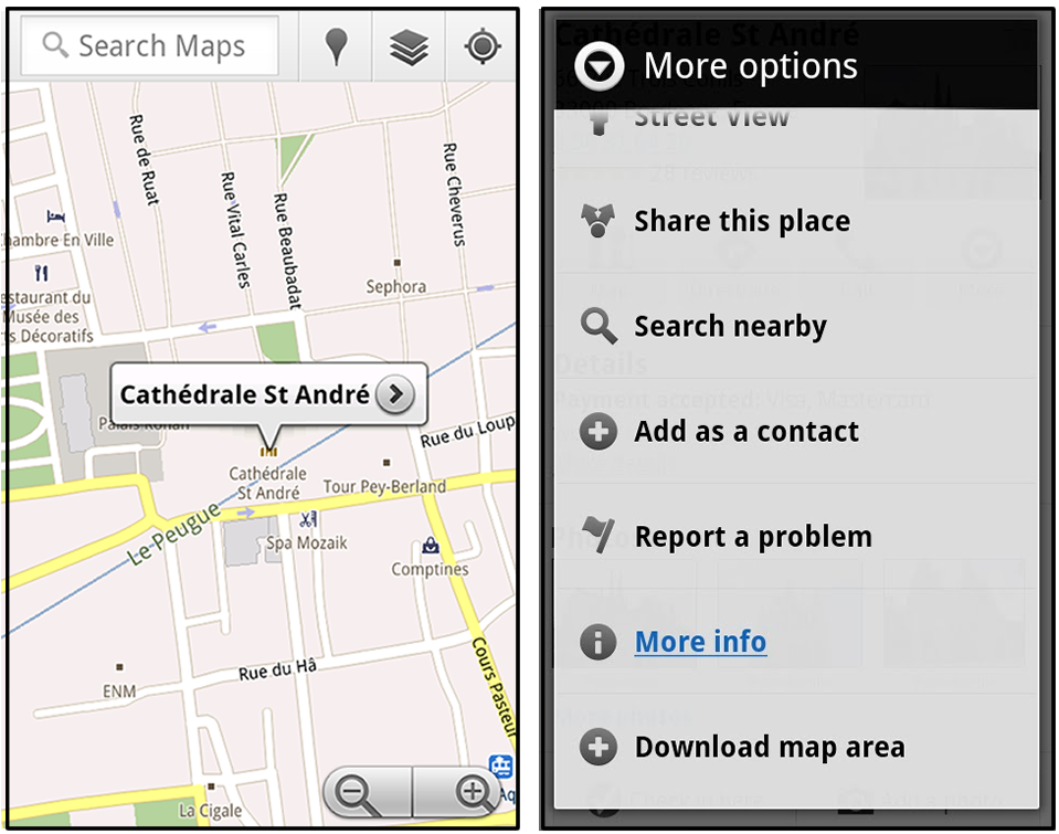
Cathedrale St. Andre. But a little advance planning and “Download map area” can help. Before you take your trip, while you still have access to WiFi or data coverage, you can open up any Places page in the world, click “More” to get the Place page menu, and download Google’s maps for a 10-mile radius.


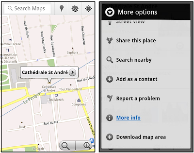
Left: Tap a landmark to enter its Place page. Right: Place page “more options” menu

The download can take as little as a minute or two. This download stores only the base map tiles and the landmarks on the map, so you still need a data connection to see satellite view and 3D buildings, search for Places and get directions. But we hope the level of detail available will help you find your way!


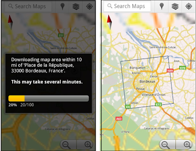
Left: Status screen for download. Right: Coverage of downloaded map area

All your downloaded map areas can be managed in your Google Maps cache settings so you can delete maps you no longer need or if you want to free up storage. After 30 days, all downloaded map areas will be removed from your cache; they can be re-downloaded any time.

Scale bar
Google Maps has approximately 20 different zoom levels that range from a 2,000 mile scale to a 20 foot scale. With finger gestures making it really quick and easy to zoom in and out, sometimes it’s not always clear what zoom level you’re at. What might be just a few streets away can be quite a long walk depending on the scale. To help with this, you can turn on a scale bar, which updates based on your zoom level.


Scale bar in the lower left
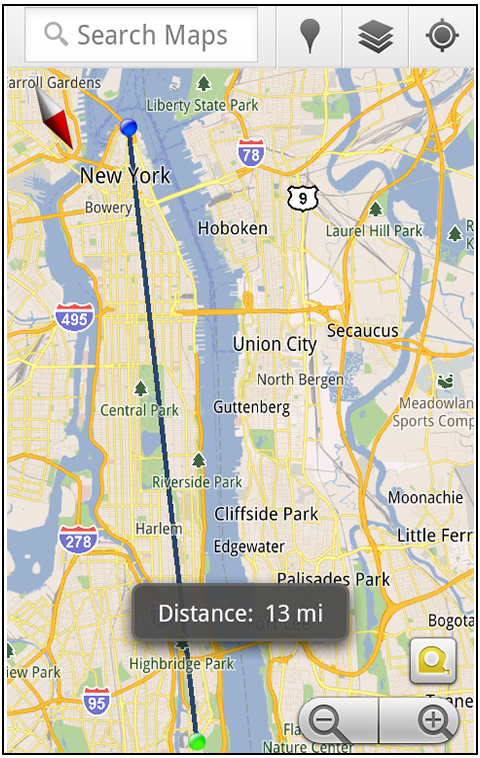
Measure
If you ever need to know the distance between San Francisco and New York (about 2602 miles) or between any other two points on the map, the “Measure” lab can help you out. Once it’s enabled, you’ll notice a tape measure icon just above the zoom buttons. After clicking that icon, you’ll be prompted to tap two points on the map and Google Maps will calculate the straight distance between those points (this direct distance is “as the crow flies”).


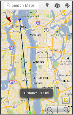
Example of the “Measure” Labs feature

To access Labs on your phone, press your phone’s menu button once in Google Maps, choose “More” and select Labs. On a tablet, click the menu button in the upper-right corner of Maps. The “Download map area” lab requires Android 2.1+ and the latest version of Google Maps. We look forward to bringing you more experimental features soon and hope you enjoy trying out Labs in Google Maps for Android.

Google Maps 5.7 for Android introduces Transit Navigation (Beta) and more

(Cross-posted on the Google Lat Long Blog and the Google Mobile Blog)

Today we’re releasing Google Maps 5.7 for Android. From Bangkok to Baltimore, we’ve added Transit Navigation (Beta), updated access to directions, better suggested search results and a photo viewer to Place pages—all of which can help you whether you’re traveling to an unfamiliar part of town or visiting a city across the world.

Transit Navigation (Beta)
Google Maps Navigation (Beta) currently provides over 12 billion miles of GPS-guided driving and walking directions per year. Now, GPS turn-by-turn (or in this case, stop-by-stop) navigation is available for public transit directions in 400+ cities around the globe with Transit Navigation.


Transit Navigation uses GPS to determine your current location along your route and alerts you when it’s time to get off or make a transfer. This is particularly helpful if you’re in a city where you don’t speak the language and can’t read the route maps or understand the announcements. After starting your trip with Transit Navigation, you can open another application or put your phone away entirely and Google Maps will still display an alert in your notification bar and vibrate your phone when your stop is coming up.


Left: Transit directions without Navigation. Right: with Navigation


Navigation alerts appear even if you switch to another app

Now you can spend more time enjoying the sights out the window and less time worrying about how many stops are left, where you are along the route or whether you missed your stop. Since Transit Navigation relies on GPS signals, we recommend using this feature for above-ground transit.

Updated Directions
Now that we’ve improved our directions services, we wanted them to be incredibly easy to pull up on your screen. If you select the driving or walking icon and your route is supported by Google Maps Navigation, the Navigation icon will automatically appear so you can get access to step-by-step directions in one click. Note: this change is currently only in place for driving and walking and does not appear for public transit.


One-click access to Navigation from directions

We’ve also streamlined how you access directions from within a Place page. Before, clicking directions in a Place page would bring up options for “Driving Navigation,” “Walking Navigation” and “Directions.” Now, you’ll be taken straight to the map and see the new directions box shown above.

Improved Search Suggest
We’ve made two changes to search suggestions that improve their quality and speed. First, we’ve added category icons, so instead of all search suggestions displaying the same icon, the icon next to the listing will reflect the type of result. You’ll see a pin for a Google Places listing, a star for a starred Place or location, a clock for a previously used search term, a person for contacts and a magnifying glass for “anything else.”


Two examples of search suggest with new icons

Also, any place you got directions to or called directly from its Places page will be included as a suggestion for a relevant search. For example, if you recently received directions to the U.S. Post Office on Wilshire Boulevard, afterward, when you begin a search with [p] or [bou], that U.S. Post Office would appear as a search suggestion.

Photo viewer for Place pages
Since we released business photos for Place pages last October, millions of photos have been added to Place pages around the world. To enable you to view these photos on the run, a slick new photo viewer has been added so you can browse photos while deciding where to go.


Left: Business photos in Place pages. Right: New photo viewer

To start using Google Maps 5.7 for Android, download the update here. This update requires an Android OS 2.1+ device and works anywhere Google Maps is currently available. Learn more at our help center and have fun exploring, whether it be by car, transit, bike or foot.

Watch the lunar eclipse from anywhere

(Cross-posted on the YouTube and Lat Long blogs)

We’re always fascinated by the unique wonders of space and the world—what can we say, it’s the geek in us! Naturally, when we learned that part of the world will be treated to a rare 100-minute long total lunar eclipse starting at 11:20am PDT today, we were both excited and disappointed that this rare occasion wouldn’t be visible from our Mountain View campus like last year’s eclipse. We suspect we aren’t alone, so you’ll be glad to know that we’ve worked with Slooh Space Camera to let you experience the spectacle wherever you are in the world, in real time.

Slooh will host a live mission interface using Google App Engine that lets anyone not lucky enough to live in certain areas (South America, Europe, Africa, Asia and Australia) take part in this rare astronomical event. It’s equipped with audio narrations from real-life astronomers so you can hear a firsthand, expert account of the event. You can also watch the live stream on the Google YouTube Channel or from the Sky layer in Google Earth (download this kml), while exploring the fascinating world that exists in our galaxy. Finally, those of you on the go can download the Slooh Space Camera Android app to view the images right on your phone.


If you're fortunate enough to be able to view this event in the sky, we hope you'll get the chance to step outside and indulge in the spectacle. For everyone else, we hope our moon madness helps brighten your day.

Update 11:23 PDT: Starting now, if you visit the Google homepage you’ll see a special interactive doodle, which will update throughout the day to show the latest state of the moon. Lunar imagery provided by Slooh.

Know when your bus is late with live transit updates in Google Maps

(Cross-posted on the Lat Long Blog and Mobile Blog)

Often when I’m taking public transit, I arrive at my stop on time only to anxiously check my watch and look down the street for my bus, which is running late once again. Those extra minutes I’m forced to wait seem like an eternity, and the only information I can access on my phone is when the bus was supposed to arrive.

Starting now, Google Maps for mobile and desktop can tell you when your ride is actually going to arrive with new live transit updates. We partnered with transit agencies to integrate live transit data in four U.S. cities and two European cities: Boston, Portland, Ore., San Diego, San Francisco, Madrid and Turin.


When you click on a transit station or plan a transit route with Google Maps and there are delays or alerts related to your trip, you’ll now see “live departure times” (indicated with a special icon) and service alerts.

Live transit departure times after tapping on a station

Live service alerts when receiving transit directions

Live departures and alerts on desktop

We’re working with our public transit partners to help them provide live data to more people in more cities. You can get live transit updates in the latest version of Google Maps for mobile (requires Android 1.6+), as well as Google Maps on all supported desktop and mobile browsers.

Google Transit goes to Washington

Every day, many thousands of commuters, locals and tourists ride public transit in Washington, D.C. To help all of these transit riders find their way around the metro area, today we’re making comprehensive information about D.C.’s public transportation available on Google Transit.

In partnership with the Washington Metropolitan Area Transit Authority (WMATA), we’re adding all of D.C.’s Metro and bus stations, stops and routes, as well as connections to other transit systems in nearby cities. You can find this information on Google Maps as well as Google Maps for mobile—no matter where you are, you can get to where you’re going. With Google Transit, D.C. metro-area commuters—including those in Baltimore, Montgomery and Jefferson counties—may discover a quicker route to work, while visitors can easily make their way from the airport straight to the Smithsonian.


Public transportation is a vital part of city infrastructure and can help alleviate congestion and reduce emissions. However, planning your trip on public transit can be challenging, especially when there are multiple transit agencies and you need to use information from multiple sources to figure out the best route. With mapping tools like the transit feature, we’re working to make that easier.

Directions are also available on Google Maps for mobile—so if you’re graduating from George Washington University and want to meet some friends at Adams Morgan to celebrate, it’s as easy as pulling out your phone. If you’re using an Android device, for example, search for Adams Morgan in Google Maps, click on the Places result and select “Directions.” Switch to Transit in the upper left corner and find out which bus will take you there the fastest.


Wherever your journey takes you, whether using public transit, driving, biking or walking, we hope Google Transit directions in D.C. make finding your way a little easier.

Google moms share tech tips for your family

As a Googler I often take my work home with me—in a good way. With two young boys at home, life is always busy, so my husband and I are always looking for ways to save time, get organized and enrich our lives in simple ways. Because the products I beta test and use in the office have become an integral part of my own family life, for Mother’s Day this weekend I’d like to share some favorite tips, including a few from other Googler parents.

Capturing and sharing memories
  • Instead of keeping 500 crayon masterpieces, store digital photos of all your kids’ artwork in Picasa Web Albums
  • Collect trip or party photos in one place by letting all of your paparazzi upload their snapshots to a collaborative online album
  • Tag friends and family in Picasa photos so you can easily create and share personalized collages, gift CDs/DVDs or movie slideshows
  • Use Picnik to edit your Picasa Web Albums photos. Use the “Create” tab to add text, stickers, frames and other effects to your photos—your kids can help, and you can email them as digital cards to distant relatives
  • Safely share home videos with family by inviting them to view a private YouTube video
  • Keep a running family history by encouraging relatives around the world to contribute stories and biographies in a shared Google doc or blog
Communicating and entertaining
  • Video chat through Gmail for free with long-distance grandparents and friends—this is also great for connecting kids with their parents when traveling
  • Entertain kids on the run with kid-friendly YouTube channels—like Sesame Street and School House RockAndroid apps or your own photos and videos on your mobile phone (kids love watching themselves!)
  • Have your kids help you create a video card or a cartoon on YouTube
  • Explore the world from the couch—fly around Google Earth on your mobile phone or tablet
  • On camping trips, use Sky Map to explore and name constellations. You can even travel back in time to show your kids what the sky looked like on the day they were born
  • Read the classics—like Anne of Green Gables, The Wind in the Willows and Grimm’s Fairy Tales—for free from Google eBooks; for older kids, many books that are required reading for school are also free. Google eBooks are accessible and readable on devices your family probably already has—like laptops or smartphones
My son Kai chatting with his dad while on a business trip

Organizing and planning
I hope these tips inspire moms (and dads) to celebrate your family this weekend. Here’s hoping you can save time and energy to focus on having fun with your kids!

Using the power of mapping to support South Sudan

Last Thursday, the Google Map Maker team, along with the World Bank and UNITAR/UNOSAT, held a unique event at the World Bank Headquarters in Washington, D.C., and a satellite event in Nairobi at the same time. More than 70 members of the Sudanese diaspora, along with regional experts from the World Bank, Sudan Institute, Voices for Sudan, The Enough Project and other organizations gathered together to map what is expected to become the world’s newest country later this year: the Republic of South Sudan. UN Secretary-General Ban Ki-moon has asked the international community “to assist all Sudanese towards greater stability and development” during and beyond this period of transition.

South Sudan is a large but under-mapped region, and there are very few high-quality maps that display essential features like roads, hospitals and schools. Up-to-date maps are particularly important to humanitarian aid groups, as they help responders target their efforts and mobilize their resources of equipment, personnel and supplies. More generally, maps are an important foundation for the development of the infrastructure and economy of the country and region.

The Map Maker community—a wide-ranging group of volunteers that help build more comprehensive maps of the world using our online mapping tool, Google Map Maker—has been contributing to the mapping effort for Sudan since the referendum on January 9. To aid their work, we’ve published updated satellite imagery of the region, covering 125,000 square kilometers and 40 percent of the U.N.’s priority areas, to Google Earth and Maps.

The goal of last week’s event was to engage and train members of the Sudanese diaspora in the United States, and others who have lived and worked in the region, to use Google Map Maker so they could contribute their local knowledge of the region to the ongoing mapping effort, particularly in the area of social infrastructure. Our hope is that this event and others like it will help build a self-sufficient mapping community that will contribute their local expertise and remain engaged in Sudan over time.

We were inspired by the group’s enthusiasm. One attendee told us: “I used to live in this small village that before today did not exist on any maps that I know of...a place unknown to the world. Now I can show to my kids, my friends, my community, where I used to live and better tell the story of my people.”


The group worked together to make several hundred edits to the map of Sudan in four hours. As those edits are approved, they’ll appear live in Google Maps, available for all the world to see. But this wasn’t just a one-day undertaking—attendees will now return to their home communities armed with new tools and ready to teach their friends and family how to join the effort. We look forward to seeing the Southern Sudanese mapping community grow and flourish.

Google Earth optimized for Android-powered tablets

When we launched Google Earth in 2005, most of us were still using flip phones. At the time, the thought of being able to cart around 197 million square miles of Earth in your pocket was still a distant dream. Last year, that dream came to fruition for Android users when we released Google Earth for Android. With the recent release of tablets based on Android 3.0, we wanted to take full advantage of the large screens and powerful processors that this exciting new breed of tablets had to offer.

Today’s update to Google Earth for Android makes Earth look better than ever on your tablet. We’ve added support for fully textured 3D buildings, so your tour through the streets of Manhattan will look more realistic than ever. There’s also a new action bar up top, enabling easier access to search, the option to “fly to your location” and layers such as Places, Panoramio photos, Wikipedia and 3D buildings.

Moving from a mobile phone to a tablet was like going from a regular movie theatre to IMAX. We took advantage of the larger screen size, including features like content pop-ups appearing within Earth view, so you can see more information without switching back and forth between pages.

One of my favorite buildings to fly around in Google Earth has always been the Colosseum in Rome, Italy:


With the larger tablet screen, I can fly around the 3D Colosseum while also browsing user photos from Panoramio. The photos pop up within the imagery so I can interact with them without losing sight of the Colosseum and its surroundings. Also, by clicking on the layer button on the action bar, I can choose which layers I want to browse.

This version is available for devices with Android 2.1 and above. The new tablet design is available for devices with Android 3.0 (Honeycomb) and above. Please visit the Google Earth help center for more information.

To download or update Google Earth, head to m.google.com/earth in your device’s browser or visit Android Market. Enjoy a whole new world of Google Earth for tablets!

Celebrating Arbor Day with Save the Redwoods League and Google Earth

From time to time we invite guests to post about topics of interest and we’re pleased to have Emily Limm join us for U.S. Arbor Day. Emily is the science director for the non-profit Save the Redwoods League and is studying the impact of climate change on the redwood forests of northern California. To raise awareness about the League’s research, she worked with Google Earth Outreach to model old-growth redwoods on Google Earth. In this post, Emily shares her ideas on how technology and citizen science can help scientific research. -Ed.

Today is U.S. Arbor Day, a holiday established 120 years ago to celebrate our often under-appreciated forests, which provide us with necessities like clean air and drinking water as well as small pleasures like shade for a summer’s day picnic or a beautiful place to hike with crunchy leaves underfoot. Arbor Day holds special meaning for me because I spend most of my time in the coastal redwood forests of California, working to protect the world’s tallest tree species.

Over the past few months, Save the Redwoods League and the Google Earth Outreach team have collaborated to create 3D models of the old-growth redwood forest in Jedediah Smith Redwoods State Park in northern California, so you can now take a virtual hike among the ancient trees and cruise over towering treetops. Explore the park by activating the 3D trees layer in Earth (under 3D Buildings) and searching for [jedediah smith redwoods state park, ca]. Tilt your view angle toward the horizon to make the trees appear. You can download the KML file for the narrated tour about redwoods to view in Google Earth, or watch the video version below:


In order to protect redwoods in Jedediah Smith and elsewhere, my colleagues and I are working to collect data on geographic regions where the trees are currently thriving to determine how future forests will fare in our changing climate. A critical piece of our work is collecting and comparing field observations of redwoods across different climates, but we need more data to draw strong conclusions—and that’s where you come in.

Today, Save the Redwoods League is launching our citizen science project Redwood Watch, powered by iNaturalist.org, a platform for recording, organizing and mapping nature observations. By sharing a simple digital photograph of a redwood tree and the time and location where the picture was taken, you can help the League track and monitor the species. If you know of a redwood tree—perhaps in your own backyard or in a nearby park—you can use the free Redwood Watch iPhone application or your own camera to take a photo, add a comment and submit it online. iNaturalist stores your observation and, if geographical coordinates weren’t captured automatically, uses the Google Maps APIs to assign them to your photo. With your geolocated observation, we can zoom out and analyze your observation in the context of global environmental and climatic patterns.

An observation of a coast redwood submitted to the Redwood Watch on iNaturalist.org.

The more field observations Save the Redwoods League collects, the better we’ll understand what climate makes a healthy redwood today, and predict where the redwood forests of tomorrow will thrive. We hope to see you on the Redwood Watch.

Happy Arbor Day from Save the Redwoods League and Google Earth!

Note: There are plenty of parallel projects going on around the world, so if you don’t live near redwoods, consider participating in one of the other iNaturalist.org citizen science projects.

Google Workshops: a place for Googlers to get their hands dirty

This is the latest post in our series profiling entrepreneurial Googlers working on products across the company and around the world. Here, mechanical engineer Dan Ratner gives you a peek at a collection of machine workshops on campus that were used to construct the prototypes for the Street View trike, snowmobile and trolley, among other personal and 20 percent time projects. -Ed.

Wood, metal, welding and electronics shops are probably not what come to mind when you think about Google but in fact, we often have to build physical products to help us collect and organize information that’s found outside of the web. We do this at the Google Workshops, a hands-on facility equipped with everything from an oscilloscope to a miter saw and even a plasma cutter. Day and night—and even on weekends—the workshops are alive with Googlers working on personal projects—such as home furniture or model airplanes—as well as work-related ones like green business prototypes or components of our self-driving cars.

Googlers using a MIG welder in one of the workshops

In 2007, I took a trip to Barcelona, where I became inspired to share with the world the magnificent architecture lining the narrow alleys through which even a Smart Car can’t squeeze. When I returned home and saw a pedicab pedaling along the pier in San Francisco, I decided how I was going to do it. That spark of an idea became the Street View trike, which collects outdoor imagery from parks and cultural sites, and was my first attempt at creating a mobile unit to traverse areas unreachable by car. Over a weekend, a couple of engineers and I hacked together a somewhat rudimentary trike design and quickly followed that up with a second and better prototype that enabled us to capture usable imagery during a test run at Emerald Park in Dublin, Calif. Our initial images proved that the concept was feasible, and after a bit more work on both hardware and software, we were invited to use our prototype trike around Legoland, our first participant in the Street View Partner Program. Our prototype and 20 percent project eventually evolved into a production-quality trike fleet and full-scale operation employing many Googlers around the world.

Me on the Street View trike, capturing imagery in Legoland

People have asked us to visit historical buildings, national landmarks and other places that even a trike can’t reach—and we’re always trying to find new ways to do so. However, designing a new vehicle requires more than just sticking a camera on top of an apparatus. We often spend hours in the workshops testing out entirely new components made out of wood, metal and—it must be said—quite a bit of duct tape in order to find new and better ways to capture remote imagery. We worked extensively in our own facilities on components of the Street View snowmobile and trolley—from wiring up electronics to milling metal.

Our first prototypes sometimes start out rough around the edges—the first trolley prototype was actually built from an off-the-shelf, narrow dolly designed for schlepping around beer kegs—but our polished production vehicles wouldn’t exist if we didn’t first make early stage “hack” prototypes in our workshops.

Innovation at Google comes in many forms—it can be an idea, a program or even a handmade prototype. For me, it’s in a workshop with a table saw, 3D printer, TIG welder, vertical mill and a variety of raw materials. As a robotics enthusiast and mechanical engineer, these are the kinds of challenges and opportunities that bring me back to work every day.

We're always looking for new and exciting sites to explore. If you'd like to include your property in Street View, please visit our submission form.

Add your local knowledge to the map with Google Map Maker for the United States

[Cross-posted from the Google Lat Long Blog]

Before Google Map Maker—a product that enables people to add to and update the map for locations around the world—only 15 percent of the world’s population had detailed online maps of their neighborhoods. Using Map Maker, people have built out and edited the maps for 183 countries and regions around the world, and now, due to the contributions of citizen cartographers, 30 percent of people have detailed online maps of the places they live.

Map Maker users have mapped entire cities, road networks and universities that were never previously recorded online. These contributions have been incorporated into Google Maps and Google Earth, so the collective expertise of the Map Maker community benefits the millions of people using these products globally.

Today we’re opening the map of the United States in Google Map Maker for you to add your expert local knowledge directly. You know your neighborhood or hometown best, and with Google Map Maker you can ensure the places you care about are richly represented on the map. For example, you can fix the name of your local pizza parlor, or add a description of your favorite book store.


You can help make the map complete in other ways as well, such as marking the bike lanes in your town or adding all of the buildings on your university campus so they appear in Google Maps. We’ve seen incredibly detailed contributions from power users worldwide, including this comprehensive map of IIT Bombay. We’re eager to see you add the same level of detail to locations in the United States.


Indian Institute of Technology Bombay

To confirm Map Maker user contributions are accurate, each edit will be reviewed. After approval, the edits will appear in Google Maps within minutes—dramatically speeding up the time it takes for online maps to reflect the often-changing physical world. To see examples of what people around the world are adding to Map Maker, you can watch mapping in real-time.

In addition to opening Map Maker for the United States, we’ve added some new features for users globally. You can now get a street-level perspective on places with Street View imagery directly in Map Maker, see and edit all points of interest, and find exactly what you’re looking for with advanced search options such as displaying all railroad tracks.

Browsing all points of interest in downtown Palo Alto, California

To learn more, check out our getting started site, or start mapping now at mapmaker.google.com.

Hotpot is going Places

(Cross-posted from the Google Places Blog)

Last November, we introduced Hotpot, our recommendation engine to help people discover great new places when they search on Google. It’s simple: Rate and review the places you know, add friends whose opinions you trust and we serve you up personalized recommendations based on those tastes.

Since then, we’ve released an iPhone and Android app, integrated Hotpot recommendations into Google.com and Google Maps, expanded to more than 47 languages and enabled people to share their ratings and reviews to Twitter. While busy iterating on the product side, we’ve also launched marketing and community campaigns in five cities in the U.S.: Portland, Ore.; Austin, Texas; Las Vegas, Nev.; Madison, Wis.; and Charlotte, N.C.

It’s been incredibly exciting to watch Hotpot grow—the community has quickly expanded to millions of users who are rating more than one million times per month and enjoying a truly personalized view of the world. Based on this success, we’ve decided to graduate Hotpot to be a permanent part of our core local product offering, Google Places. Rolling Hotpot into Google Places helps simplify the connection between the places that are rated and reviewed and the more than 50 million places that already have an online presence through Google Places—places that millions of people search for and find every day on Google.


Many of you first asked us at Hotpot’s launch: Why the name? Hotpot, the dish, describes a shared eating experience. To us, the name embodied the communal experience of sharing your ratings and reviews with friends, and getting recommendations in return.

Though the name Hotpot may be going away, you can expect even more “Hotpotness” in Google Places. We have big plans to continue adding more features to Google Places that make it even easier to rate, discover and share the places you love whenever you’re using Google. So stay tuned to the new Google Places Blog for product updates, tips, tricks and news from our city campaigns.

New imagery of Japan after the earthquake

(Cross-posted from the Lat Long Blog)

It’s now the third week after the devastating 9.0-magnitude earthquake that struck northeastern Japan. Aid organizations have been hard at work and cities are starting to show signs of recovery, but the damage is beyond imagination and there are still thousands of people at shelters grappling with daily challenges. As a native of Sendai city, I’m still speechless seeing the destruction and damage that has been done to the places I love and care about.

We’ve been looking for ways we can assist in the relief efforts using Google’s map-related tools. A few days after the quake, we published updated satellite imagery of northeast Japan in Google Maps and Google Earth, which illustrated the massive scale of devastation in the affected areas.

Today, we’ve published imagery of the Sendai region at even higher resolution, which we collected on Sunday and Monday. The new Sendai imagery, along with satellite imagery from throughout the area, is now live in the base imagery layer of Google Earth and will soon be visible in Google Maps. We hope to continue collecting updated images and publishing them as soon as they are ready.

We hope our effort to deliver up-to-date imagery provides the relief organizations and volunteers working around the clock with the data they need to better understand the current conditions on the ground. We also hope these tools help our millions of users—both those in Japan and those closely watching and sending their support from all over the globe—to find useful information about the affected areas.

A riverside neighborhood in Sendai from our newly released imagery

When in Rome: New Street View imagery of historic sites in Italy and France

(Cross-posted on the Lat Long Blog)

We’ve been busy pedaling the Street View trike around the nooks and crannies of storied sites in Europe, including palaces, monuments and castles, so you can explore them in Google Maps with Street View.

Starting today, you can view some of the most historic and architecturally significant landmarks in Italy and France, including UNESCO sites in Rome, the center of Florence and stunning chateaux in the French countryside.

In addition to seeing the exterior of archaeological sites like the Imperial Forum and the Colosseum in Rome, you can now explore inside the Colosseum and imagine yourself viewing naumachiae—simulated sea battles for which the Colosseum was filled with water—or speaking with statesmen inside the Imperial Forum.

Inside the Colosseum, Rome

In few clicks you can navigate through centuries of history. Start at the birthplace of Rome, the Palatine Hill, where the mythical founders of the city, Romulus and Remus were found and saved by a she-wolf, and where the most ancient buildings of the city are located. Follow the Appian Way, a little path that became one of the most strategically important roads of ancient Rome. After the long walk, experience the splendor of Imperial Rome at the Thermae (Baths) of Diocletian—ancient wellness and cultural centers with 33 acres of pools, gymnasiums and public libraries.

Baths of Diocletian

After wandering around Rome, you can fast forward in time to witness the celebrated architectural wonders of the Italian Renaissance, including Giotto’s Campanile (bell tower) and Brunelleschi’s Cupola (dome) in Santa Maria del Fiore in Florence. While in Florence don’t miss the opportunity to walk through Ponte Vecchio and shop at the famous artisan jewel stores built on top of it!

Santa Maria del Fiore, Florence

In France, you can view picturesque chateaux and indulge your fantasies of living like French royalty by taking a virtual stroll around the beautiful Fontainebleau.

Château de Fontainebleau

Start exploring these sites in our Street View gallery, or find your favorite historic spots directly in Google Maps.

Baseline to baseline, we’ve got the basketball games covered

(Cross-posted on the LatLong and Student blogs)

Do you hear the dribble on the court and the chanting of the fans? Following an action-packed week of buzzer beaters, the 2011 NCAA® Championship here in the U.S. promises to be as exciting as ever.

As a college hoops fan, I often wish I could experience the games sitting in the arenas—and I’m sure I’m not alone. This year, our college basketball tournament map lets you get as close as you can to the games without leaving your desk thanks to 3D models of the tournament’s 14 arenas. Take a virtual tour of the venues by watching the video below, or download this tour and open it in Google Earth.


Plus, we’ve created a special page for you to keep track of all the excitement during the next few weeks. You can see an up-to-date tournament schedule, explore the college campuses in Street View and click through to watch the actual games on NCAA® March Madness on Demand®. You can also create a bracket using Google Docs, read Google News articles on the games and download basketball apps from the Chrome Web Store. It’s all here (along with a fun surprise) at www.google.com/collegebasketball2011.

And since there’s been a long-running debate over whether teams playing closer to their home court have an advantage, we added a “Distance Tool” on the map to make it easier to measure how far schools have to travel from game to game. We’ll see how things play out, but the defending champion Duke Blue Devils may have to travel more than 2,000 miles to Anaheim if they win their first two games.


As my friends always say when we can’t wait for the tournament to begin, “Send it in, Jerome!” May your favorite school reach the finals and we hope you enjoy all the basketball fun at www.google.com/collegebasketball2011.

Post-earthquake imagery of Japan

(Cross-posted from the LatLong Blog)

In response to the devastating earthquake and subsequent tsunami that struck Japan, we’ve worked with our satellite imagery providers to get the latest available data of the areas affected most.

To view this high-resolution imagery, courtesy of our partners at GeoEye, download this KML file and explore it in Google Earth. You can also explore the imagery with Google Maps, or have a look at this Picasa album of before-and-after shots. Here’s a sample:

Before and after the earthquake and tsunami. Above is Yuriage in Natori, below is Yagawahama; both are in Miyagi prefecture. High-resolution version of this photo.

We’re working to provide this data directly to response organizations on the ground to aid their efforts. We hope this new updated satellite imagery is valuable for them as well as everyone else following this situation to help illustrate the extent of the damage.

You can find more information regarding the disaster and resources for those in need at our Crisis Response page in English and Japanese. You can also follow @earthoutreach on Twitter to stay up to date with our mapping and imagery efforts.

A fairytale marriage: Google Earth and London in 3D

(Cross-posted on the Lat Long Blog)

On April 29, the eyes of the world will focus on London for the royal wedding of Prince William and Catherine Middleton, and the U.K. will deliver a royal celebration that will capture the imagination of a global audience. We’re doing our part too: following last week's announcement of new aerial imagery for London, we’re expanding our 3D imagery of central London’s buildings and trees in Google Earth—including the entire royal procession route.


With this new 3D data covering the royal procession route, you can indulge yourself in a “royals’-eye” view to see the same sights that William and Catherine will see. Upon departing Westminster Abbey, you’ll pass the Houses of Parliament and Big Ben, the famous ministries on Whitehall and the Prime Minister’s residence at 10 Downing Street. Traverse Horse Guards Parade, and from there, you can travel down The Mall—with 3D trees lining the route—and see Buckingham Palace standing proudly at the finish.

This new 3D imagery isn’t limited to the royal parade route. Thousands of buildings are available, so people from around the globe can digitally experience the beauty of London. You can view buildings such as the British Museum, a treasure trove of historical artifacts, Goodge Street tube station, where General Eisenhower commanded allied forces in WWII, and Shaftesbury Avenue, the historical theatre district of London.

What’s more, we’ve also turned St James' Park, Green Park and Hyde Park into a 3D lush green carpet, thanks to the help of our friends at the Royal Parks. We’ve modeled five different species of trees, and virtually planted more than 12,000 individual trees (available in Google Earth 6).

To see all the landmarks and greenery in Google Earth, check the 3D buildings box in the left-hand panel under “Layers,” type “London” in the search bar on the top left and use the navigation controls in the upper right to zoom in, spin around and tilt the view. Or you can go to Earth View on Google Maps in your browser.

Since moving to London from Leek, in Staffordshire, I’ve grown to appreciate all the royal and historic landmarks in the capital. So whether you’re standing near me and millions of my fellow Britons on the Mall on April 29 to catch a glimpse of the happy couple, or enjoying the spectacle from home, I hope this new 3D data for London brings you closer to this wonderful city.

A preview of the sunrise on April 29